OUTDOOR / LARGE SCALE ENVIRONMENTS / ALL-WEATHER / QUICK DEPLOYMENT
Wide-area Camera Tracking for AR in Live Events, Sports Broadcasting and Outdoor Productions

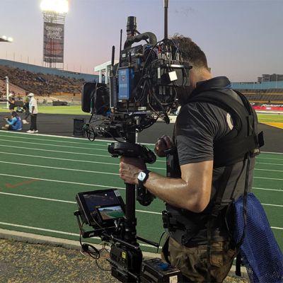
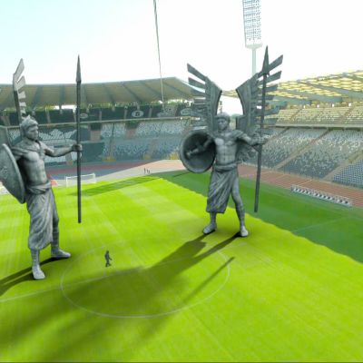
AirPixel XT delivers high-precision camera tracking for dynamic AR graphics in large-scale, uncontrolled environments like racetracks, stadiums, golf courses, and festivals—where optical systems often fail. It provides real-time position and orientation data (pan, tilt, roll) without line-of-sight limitations or lighting interference.
Ideal for immersive sports coverage and live event visuals, it supports advanced workflows such as in-camera VFX and Simulcam with integrated FIZ and genlock for seamless, frame-accurate tracking. Powered by RTK GNSS and inertial technology, AirPixel XT is built for consistent performance in demanding conditions.
Fully compatible with Unreal Engine, Pixotope, Brainstorm, Disguise, VizRT, and Zero Density, it integrates quickly into professional broadcast pipelines, delivering scalable, dependable results.
Precision Tracking for VR and Live Events
Discover why AirPixel XT is the go-to solution for real-time, wide-area, and virtual production camera tracking – offering precision 6DOF data, fast deployment, low latency, and seamless integration with industry-leading rendering platforms.

Position, Pan, Tilt & Roll (6DOF)
AirPixel XT provides accurate pan, tilt and roll plus X, Y, Z position up to 100 times a second. Advanced filtering is used, combining inertial sensor and GNSS data to significantly reduce drift.

No Lighting Restrictions
AirPixel works in all weather conditions including bright sunlight, rain, mist or total darkness.

Highly Scalable
AirPixel XT is suitable for locations with virtually unlimited size without any deterioration in position quality. From athletics stadiums to Grand Prix circuits, the potential is limitless!

No Line Of Sight Required
The use of inertial sensors and satellite positioning means AirPixel XT requires no line of sight to any additional hardware or visual markers. Only an open view of the sky is needed to receive satellite signals.

FIZ Data / Genlock Integration
AirPixel XT can read the focus, iris and zoom (FIZ) values from a variety of cameras and controllers. It seamlessly integrates FIZ data and genlock to provide a complete data set to the render engine.

Supports Major Rendering Platforms
AirPixel XT integrates with Unreal Engine and other popular rendering solutions such as Pixotope, Disguise d3, Zero Density, Brainstorm, VizRT and MotionBuilder. Data is output using AirPixel or FreeD protocol.

Quick To Deploy
The initial setup can be done in under an hour depending on stage complexity and the re-initialisation takes only 2 minutes after power up.

Low Latency
AirPixel is a low latency system suitable for all real-time applications. All data is processed on camera and transmitted with as little as 20 ms latency.

Small Payload
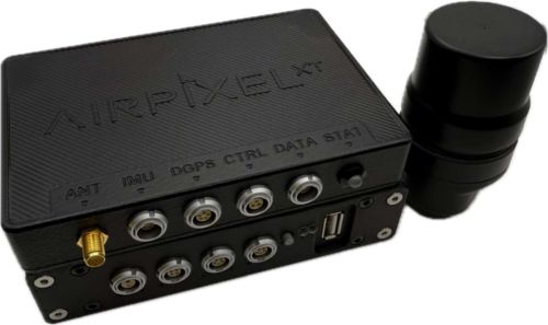
AirPixel uses a small receiver placed on the camera, plus a compact control and processing unit, weighing a combined 700 g (1.5 lb). No further processing is required.
GPS + Inertial Tracking
AirPixel XT calculates the camera’s precise position and orientation by combining satellite data with inputs from its onboard Inertial Measurement Unit (IMU). This data is processed through an advanced filtering algorithm to deliver real-time outputs for X, Y, Z position and Pan, Tilt, Roll orientation.
The system’s GNSS antenna connects to a lightweight control unit, which merges the tracking data with lens FIZ (Focus, Iris, Zoom) values, applies genlock for frame sync, and transmits the result to your render engine via Ethernet or serial connection. Output can be formatted in either AirPixel’s proprietary protocol, designed for seamless integration with our custom Live Link plugin, or in FreeD format for compatibility with most leading broadcast and AR platforms.
Fast, Accurate Setup
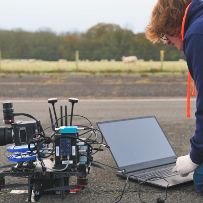
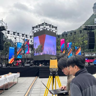
While standard satellite receivers (like those in phones or cars) provide only 1–3 m accuracy, AirPixel XT uses RTK correction to achieve centimetre-level precision. It receives correction data from either a fixed base station (image 1) or an NTRIP service via a modem (image 2), both of which can be configured within minutes, enabling rapid deployment in the field.
Built for Any Rig, Any Conditions
AirPixel XT integrates with a wide range of camera support systems, including dollies, Steadicams, jibs, cranes, and cable cams. It performs flawlessly in any lighting, even complete darkness, and is designed to work alongside third-party hardware for maximum flexibility. This allows accurate tracking data to be captured in scenarios where traditional systems fail.
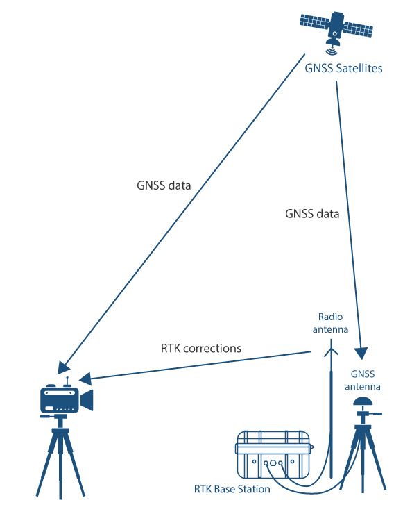
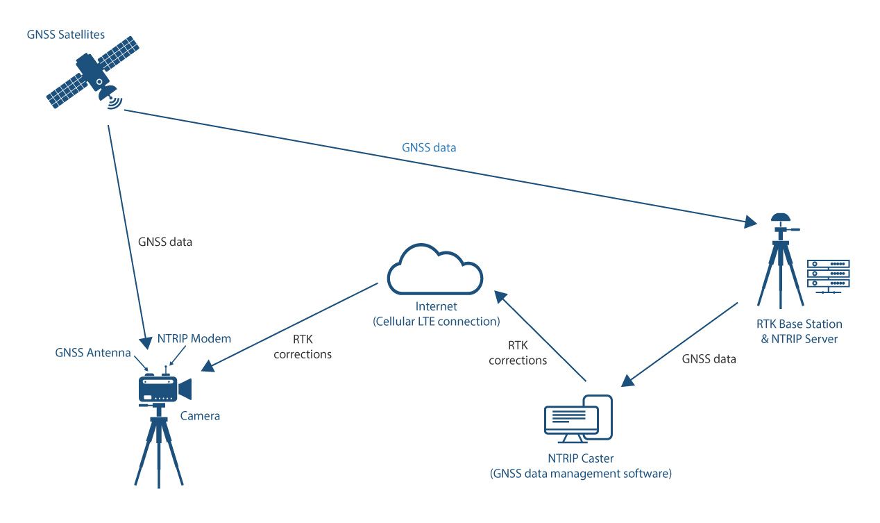
Image 1: Camera position is calculated using correction messages from a fixed base station
Image 2: Camera position is calculated using RTK correction messages from NTRIP service provider
Specifications
| Update Rate | max. 100 Hz |
| Output Rate Genlocked | 23.98, 24, 25, 29.97, 29.97 Drop, 30,47.95, 48, 50, 59.94, 59.94 Drop, 60 |
| Positional Resolution | 1 mm |
| Position Accuracy | X: ±2 cm Y: ±2 cm Z: ±5 cm |
| Angular Accuracy | Tilt : ±0.2° Roll: ±0.2° Pan : ±0.5° |
| Latency | 50 ms |
| Protocol Support | AirPixel or FreeD D1 |
| Max. tracking speed | 270 km/h; 75 metres per second |
| Max. number of tracked cameras | Unlimited |
| Time Resolution | 0.01 s |
| Time Accuracy | 30 ns |
| Power requirements | 9-30 V DC, less than 5 W power consumption incl. power to rover |
| IP rating | Not Applicable |
| Operating Temperature | -20˚C to +60˚C |
| Storage Temperature | -40˚C to +85˚C |
| Weight | Rover incl. cable: 120g / (0.27 pounds)
Processing Module: 247g / (0.55 pounds) Control Unit: 333 g / (0.73 pounds) Combined Camera Payload: 700 g / (1.55 pounds) + Cables |
| Dimensions | Rover: 43.6 mm x 69.4 mm Processing Unit:128.5 mm x 85.9 mm x 22 mm Processing Unit: 128.5 mm x 85.9 mm x 30 mm |
Camera Tracking in Action
Explore how AirPixel is redefining camera tracking across real-world environments. From wide-area camera tracking at major sports events to virtual production camera tracking on LED stages, these case studies highlight the system’s versatility, precision, and seamless integration with AR pipelines.

